Informed Decisions Start with Authoritative Intelligence
As Montezuma evolves into a pivotal hub for Macon County’s industrial and agricultural growth, the tolerance for error in site data has disappeared. For developers, municipal planners, and project managers along the Flint River corridor, traditional land surveying often fails to keep pace with the accelerated timelines of modern infrastructure. Montezuma Ag Drones provides a radical advancement in how terrain is measured. We move beyond simple "drone photos" to deliver sophisticated geospatial intelligence that serves as the definitive technical foundation for your most significant investments.
Our methodology is designed to solve the most persistent challenges of Middle Georgia surveying: expensive delays, the inherent dangers of manual site measurement, and the logistical hurdles of manned flight. Utilizing a fleet of Department of Defense-vetted Blue UAS platforms, we capture millions of precise coordinate points across massive swaths of the Coastal Plain in a single afternoon. Whether you are managing a local aggregate facility or mapping a new industrial park, we provide high-resolution results that plug directly into your existing CAD and GIS ecosystems.
The Security of Blue UAS
In an era of heightened digital risk, the provenance of your site data is a top priority. All Montezuma Ag Drones survey operations utilize Blue UAS Certified hardware, ensuring every component has undergone stringent cybersecurity auditing by the U.S. military. For stakeholders managing critical Macon County infrastructure—from power substations to regional pipelines—this certification guarantees that sensitive spatial data remains protected and compliant with federal security standards.
Volumetric Surveys: Absolute Inventory Control
For the mining, aggregate, and timber operations that drive the Macon County economy, precise inventory management is a financial imperative. Relying on "best-guess" manual measurements is no longer viable or safe for crews navigating steep highwalls or shifting stockpiles. Montezuma Ag Drones removes the human element from hazardous terrain while drastically increasing the fidelity of the data. Our 61MP high-resolution sensors capture every contour of your site to build hyper-accurate 3D reconstructions.
By processing this imagery through PIX4Dmatic, we generate verifiable cut/fill reports and stockpile totals with centimeter-level precision. For accounting departments in Montezuma, this means inventory reconciliation is transformed from a week-long headache into a transparent, 24-hour turnaround. We provide a measurable, auditable digital record of your resources, allowing for real-time asset management from any device.
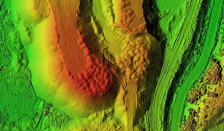
LiDAR Surveying: Seeing Through the Georgia Canopy
The dense timber and thick undergrowth of the Coastal Plain often render standard aerial photography useless for seeing the actual ground. Engineering projects in Macon County require a clear view of the topography, regardless of how thick the pines or hardwoods may be. Montezuma Ag Drones solves this through LiDAR (Light Detection and Ranging) technology. We utilize the Riegl miniVUX-2UAV, a premier laser-scanning system engineered for extreme vertical precision.
By emitting millions of laser pulses every second, our LiDAR system can thread the needle through the thickest canopy, reflecting off the soil to create a "bare earth" Digital Terrain Model (DTM). For Montezuma engineers designing complex drainage systems or developers evaluating raw land, this capability is a game-changer. Our LiDAR scans deliver absolute vertical accuracy within one inch and a density of up to 800 points per square foot, uncovering hidden elevation changes that traditional methods simply cannot detect.
Large-Scale Mapping & Multi-Crew Efficiency
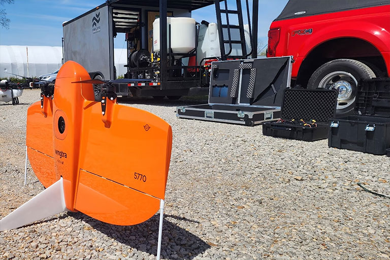
Covering vast acreages is the primary obstacle for regional development projects. While standard consumer drones lack the range for large tracts, manned aircraft are often too costly for routine monitoring. Montezuma Ag Drones utilizes the WingtraOne Gen II, a high-end VTOL (Vertical Take-Off and Landing) fixed-wing aircraft capable of mapping over 700 acres in a single flight session—outperforming quadcopters by a factor of ten. For the most expansive projects in the region, we are equipped to deploy multiple teams simultaneously to cover thousands of acres in record time.
This rapid data acquisition does not compromise quality. With integrated PPK (Post-Processed Kinematic) technology, every captured frame is geotagged with surgical precision, eliminating the need for extensive ground control networks. This reduces our physical presence on your site while delivering a massive, unified dataset ready for immediate civil engineering or land-use planning.
3D Digital Twins & Virtual Site Modeling
Move your project visualization into the third dimension with photorealistic digital twins. While flat blueprints have their place, they cannot provide the immersive spatial context required for complex site management. Montezuma Ag Drones generates measurable, high-fidelity 3D models that allow Macon County stakeholders to inspect, measure, and present their projects with unparalleled clarity.
By merging vertical and oblique imagery, we create textured 3D meshes and point clouds that serve as an "as-built" historical record. This technology is the gold standard for tracking construction milestones, conducting architectural analysis, and marketing high-value commercial real estate. For local developers, a digital twin offers a verifiable timeline of site progress, ensuring that the physical build matches the digital design at every stage of development.
Technical Accuracy Standards
Horizontal Precision
1.0 cm
Advanced PPK Integration
Vertical Accuracy
< 2.5 cm
LiDAR Surface Modeling
Ground Sampling Distance (GSD)
0.7 cm/px
Full-Frame 61MP Clarity
End-to-End Workflow
Your Montezuma-based Project Lead manages the entire process—from initial site scoping and sensor optimization to the final data delivery in Pix4Dmatic. We export data in the professional formats your team uses most: DXF, DWG, LAS, and GeoTIFF.
Request Technical Scoping